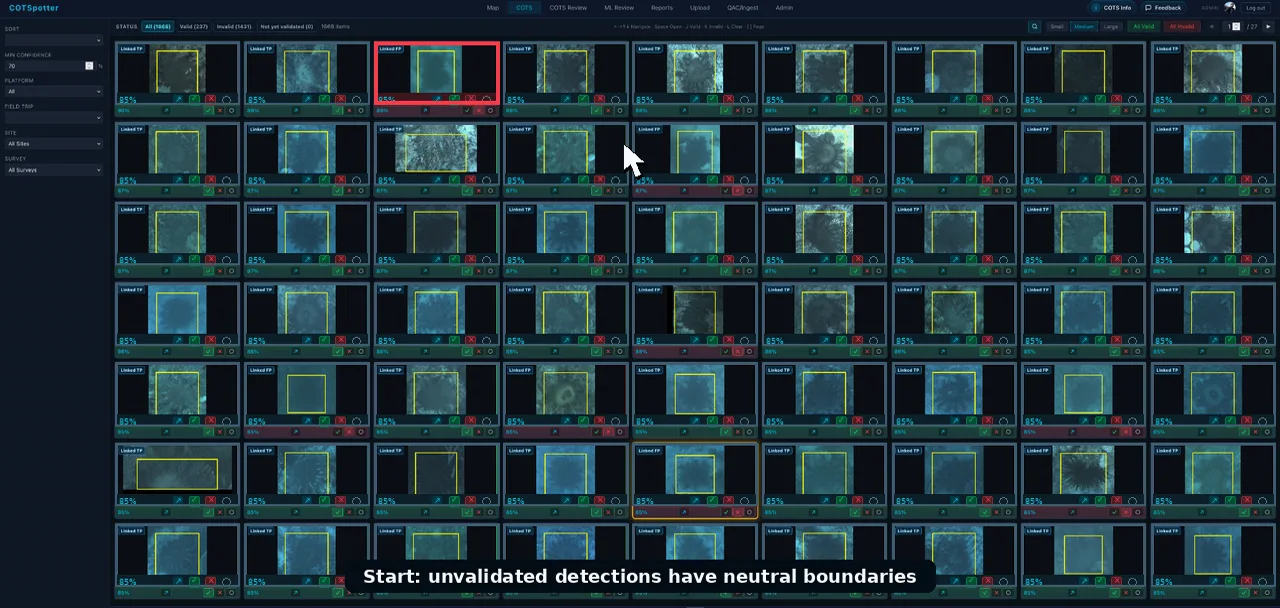
Upload & QAC
Data and metadata problems are identified while they can still be resolved.
RAW EVIDENCEReef-scale AI · human judgement
COTSpotter connects AI analysis, human validation and integrated reef data to help us see crown-of-thorns starfish sooner and act with greater confidence.
01 / NATIVE PREDATOR
The challenge
Crown-of-thorns starfish naturally feed on coral. The management problem begins when their abundance reaches outbreak levels and coral loss outpaces recovery.
Why do we need COTSpotter?
From balance to outbreak
Outbreaks are cyclical. Earlier detection provides more time to target surveillance and control before coral predation accelerates.
Three complementary views
Manta tow provides broadscale surveillance. ReefScan imagery creates persistent, reviewable evidence. Cull operations provide direct observations during targeted control. Each method answers a different question, with different constraints in coverage, timing and effort.
Different purpose. Different resolution. Different effort. COTSpotter helps connect these observations without treating them as equivalent.
Why COTSpotter
Image-based surveys create persistent evidence, but manual review of thousands of images does not scale. COTSpotter combines on-the-fly quality checks, AI-assisted detection and focused human validation to reduce the time from collection to usable evidence.
The COTSpotter workflow
COTSpotter reduces the time between image collection and reviewable evidence while preserving human judgement, provenance and uncertainty.
Data and metadata problems are identified while they can still be resolved.
RAW EVIDENCEAI identifies COTS observations across large image collections.
MACHINE ASSISTEDPeople confirm, reject or flag uncertain detections.
REVIEWEDTraceable evidence returns as maps, reports, data and APIs for planning and control.
DECISION READYCOTSpotter presents candidate detections in a focused review workflow. Validators can quickly confirm a COTS, reject a false detection, or flag an uncertain case for expert review.
Evidence across scales
Image-derived detections show promising spatial agreement with established manta tow and cull evidence. The comparison is encouraging—and still needs more matched data.
Read with care: blank areas are often gaps in effort or timing—not evidence that methods disagree. Robust comparison requires calibration for differences in method, detectability, coverage, location and timing. That calibration is also necessary before using image-derived evidence for historical trends, time-series inference or operational thresholds within COTS integrated pest management.
The current constraint
The June 2026 snapshot covers approximately 30 months of data from January 2024. Image surveys covered about one-tenth the measured distance of the established manta tow record. The smaller evidence footprint reflects lower deployment effort, while conventional image review remains labour-intensive. Automated QAC, AI triage and focused validation make expanded image collection more operationally feasible.
8,184 km ÷ 905 km = 9.04
| Method | COTS evidence | Survey / records | Effort | What it contributes |
|---|---|---|---|---|
| Cull | ~125,000 | ~28,000 | 1,444 days | Direct control evidence and a large operational record |
| Manta tow | ~3,000 | ~41,000 | 8,184 km | Long-running, broadscale visual surveillance |
| Image | 251 | 618 | 905 km | Persistent, reviewable, high-detail evidence |
Expand matched image collection and calibration to support defensible density estimates, time series and decision thresholds—not just promising spatial agreement.
Built through collaboration
Reef evidence often sits across organisational, technical and operational boundaries. Important context can be delayed or lost when field observations, imagery, analysis and management systems remain disconnected.
COTSpotter and its cloud infrastructure can provide a traceable evidence layer across those boundaries—connecting provenance, review decisions, maps and reusable data products while preserving each partner's responsibilities and data governance.
Funding, COTS Control Innovation leadership and coordination.
Management context, RJFMP field operations and workflow collaboration.
ReefScan platforms, image generation, provenance and deployment of edge AI.
TensorFlow/Kaggle origins, large-scale data collection support, and cloud, Vertex AI and Gemini technology.
AI research, integration, validation, analytics and data products.
Information for Sea Country
COTSpotter data can help Traditional Custodians see where and when COTS surveys have occurred and what was observed. Initial engagement is planned for the coming months, with the project fact sheet providing a practical starting point for those conversations.
Download the project fact sheetThe workflow is built
Help expand matched image collection, calibration and operational adoption for the people protecting the Reef.